"A Walk on the Moors" - John's Pennine Way Ramble, Day 12 - July 12th 2000, Dufton to Alston |
|---|
| Day | Date | Start | Finish | Approx. Miles | Hours Taken | Accommodation |
| 12 | Wed. 12th July | Dufton | Alston | 22 | 9 | B&B - Mr. & Mrs. Le Marie, Brownside House, Leadgate, Tel. 01434 382169 |
Click on any picture to go to a larger
version. ![]() to go to the full set of Pennine Way photographs for this
day.
to go to the full set of Pennine Way photographs for this
day.
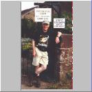
 I set off on day twelve with some trepidation. At
22 miles it was to be the longest walk I'd ever done. It crosses the highest
point of the Pennine Way (Cross Fell) and I was still worried about Noelene's
swollen face. At the café the day before, we'd heard how a young guy had
been caught on the top of Cross Fell in mist the previous day and had been
brought down suffering from hypothermia. I was very glad that the weather
seemed clear and bright and I walked in shorts for only the second time (like
the knees?).
I set off on day twelve with some trepidation. At
22 miles it was to be the longest walk I'd ever done. It crosses the highest
point of the Pennine Way (Cross Fell) and I was still worried about Noelene's
swollen face. At the café the day before, we'd heard how a young guy had
been caught on the top of Cross Fell in mist the previous day and had been
brought down suffering from hypothermia. I was very glad that the weather
seemed clear and bright and I walked in shorts for only the second time (like
the knees?).
However, I left at about 08:45, walked down to the YH and met Harry and Elaine. We went out of the village via the alternative route to the north west and then headed north along a lane and to Coatsike Farm. Here the farmer seemed to be doing his best to beautify the countryside by storing rusted, derelict farm vehicles in his field! In an area of such outstanding natural beauty it's outrageous that farmers are allowed to get away with littering the countryside with clapped out, decaying cars, old tractors and parts of them, farm machinery, cement mixers, etc. But I guess that, in this part of the world, the farmer is king and can get away with just about anything. We saw a similar instance just after Garrigill later in the day.
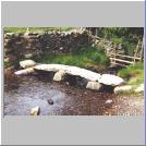
 Shortly after Coatsike Farm we
crossed a stone Clapper Bridge over Great Rundale Beck. It was very picturesque
and, I guess, pretty old too. We began to climb and the path became
increasingly steep. We crossed Swindale Beck, following a line of cairns up
Green Fell and Knock Old Man ("knock, knock, who's there, knock, old
man!"). The path then headed north west again, across some boggy bits and
flagged sections to a tarmac road heading towards the day's second blot on the
landscape, the radar dome on the top of Great Dun Fell. It's said that the
radar dome allows us to fly on our holidays to Majorca or wherever more safely
and ensures that you always know which is Great Dun Fell. Personally I'd rather
walk the Pennine Way on holiday and even my navigation isn't so bad as
to need such an enormous way marker! Off the road we headed for the dome and as
we climbed towards it the weather became colder and the wind stronger so the
sweatshirts came out and went on.
Shortly after Coatsike Farm we
crossed a stone Clapper Bridge over Great Rundale Beck. It was very picturesque
and, I guess, pretty old too. We began to climb and the path became
increasingly steep. We crossed Swindale Beck, following a line of cairns up
Green Fell and Knock Old Man ("knock, knock, who's there, knock, old
man!"). The path then headed north west again, across some boggy bits and
flagged sections to a tarmac road heading towards the day's second blot on the
landscape, the radar dome on the top of Great Dun Fell. It's said that the
radar dome allows us to fly on our holidays to Majorca or wherever more safely
and ensures that you always know which is Great Dun Fell. Personally I'd rather
walk the Pennine Way on holiday and even my navigation isn't so bad as
to need such an enormous way marker! Off the road we headed for the dome and as
we climbed towards it the weather became colder and the wind stronger so the
sweatshirts came out and went on.
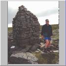
 Having passed the dome we almost ran down the very easy flagged
path and quickly climbed to the top of Little Dun Fell, not much smaller than
its grown up brother. Then there was a very long, hard climb to the top of
Cross Fell, at 893 metres (2,930 feet), the highest point on the Pennine Way.
The summit is a huge dome and because of its size and shape, like the Cheviot
as I was to read later, there are no views to be had from the top. Fortunately
the weather, which seemed to be worsening, held and, apart from a biting cold
wind and a difficult rocky climb, we reached the summit quite easily. There we
met a German guy called Stephen from, I think, Köln (Cologne) at the stone
shelter having lunch. He'd walked as far as Baldersdale last year and had only
five days to go from there to Kirk Yetholm this year. So he was doing huge
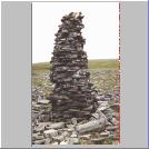
distances each day. We took a few photos of yet more cairns, of which the
summit has a large number of very impressive ones, and started the very long
trek down to Garrigill.
Having passed the dome we almost ran down the very easy flagged
path and quickly climbed to the top of Little Dun Fell, not much smaller than
its grown up brother. Then there was a very long, hard climb to the top of
Cross Fell, at 893 metres (2,930 feet), the highest point on the Pennine Way.
The summit is a huge dome and because of its size and shape, like the Cheviot
as I was to read later, there are no views to be had from the top. Fortunately
the weather, which seemed to be worsening, held and, apart from a biting cold
wind and a difficult rocky climb, we reached the summit quite easily. There we
met a German guy called Stephen from, I think, Köln (Cologne) at the stone
shelter having lunch. He'd walked as far as Baldersdale last year and had only
five days to go from there to Kirk Yetholm this year. So he was doing huge
distances each day. We took a few photos of yet more cairns, of which the
summit has a large number of very impressive ones, and started the very long
trek down to Garrigill.
I was allowed to be leader on the descent from Cross Fell and I decided to take an unofficial, alternative dry weather route down to Greg's Hut, a foul weather shelter. My special way down took us into some really boggy morasses. Looking back we saw that Stephen had followed us about ¼ mile behind. He must have been really impressed with my navigating! Just past the shelter we met the Dutch Boys again, with their boots off and munching the Mars Bars they'd bought in the pub the night before. The road down from Cross Fell is called Corpse Road because its reputed (but unproven) use in bygone times. All I know is that the descent is quite frankly a b****y awful stony track laid by another Countryside Agency bureaucrat who's never walked further than the pub in his life and I'd have liked to have made a corpse out of him. And it was hell on my poor, sore feet. Not that I'm a complaining sort, I hope you understand!
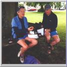
 Anyway, we eventually reached the very pretty village of
Garrigill with no mishaps. Stephen had overtaken us and, while Uncle and Auntie
ordered tea outside, I went in the pub where I found him, Peter and a much
better looking Noelene. For the one and only time on the whole Pennine Way walk
I had an excellent pint of bitter before the finish and was tempted (only
tempted, please note) to have several more. Outside, Dave and the father and
son team had caught us up and Dave had his boots off to massage his feet. I
pretended that mine didn't hurt. We're tough, us folk what live in Bolton! It
was great to sit around the tree on the village green, drinking the beer,
eating a butty and talking to the other walkers but we still had a few miles to
go so we set off for the final leg of the day.
Anyway, we eventually reached the very pretty village of
Garrigill with no mishaps. Stephen had overtaken us and, while Uncle and Auntie
ordered tea outside, I went in the pub where I found him, Peter and a much
better looking Noelene. For the one and only time on the whole Pennine Way walk
I had an excellent pint of bitter before the finish and was tempted (only
tempted, please note) to have several more. Outside, Dave and the father and
son team had caught us up and Dave had his boots off to massage his feet. I
pretended that mine didn't hurt. We're tough, us folk what live in Bolton! It
was great to sit around the tree on the village green, drinking the beer,
eating a butty and talking to the other walkers but we still had a few miles to
go so we set off for the final leg of the day.
 Noelene had booked us into Brownside House B&B, the same
place as Harry and Elaine. It's just across the River South Tyne that we were
to follow into Alston, half way between Garrigill and there. However, we missed
the turning and ended up walking right into Alston and then back to our
accommodation for the night. At least it saved us a mile or two the following
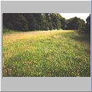
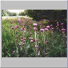
day. The path to Alston passed first through another farmer's rubbish tip (see
above) but then along very pleasant tracks, easy walking and through some
delightful meadows full of the most beautiful flowers and plants that we'd seen
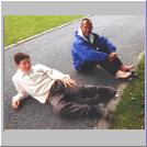
on the whole walk so far. We crossed the bridge at Alston to walk back to
Brownside House and, whilst asking for directions a dog attacked Elaine,
knocking her over but frightening her more than anything. Harry quickly put on
his lion tamer's outfit, got out his whip and bravely fought it off!
Noelene had booked us into Brownside House B&B, the same
place as Harry and Elaine. It's just across the River South Tyne that we were
to follow into Alston, half way between Garrigill and there. However, we missed
the turning and ended up walking right into Alston and then back to our
accommodation for the night. At least it saved us a mile or two the following
day. The path to Alston passed first through another farmer's rubbish tip (see
above) but then along very pleasant tracks, easy walking and through some
delightful meadows full of the most beautiful flowers and plants that we'd seen
on the whole walk so far. We crossed the bridge at Alston to walk back to
Brownside House and, whilst asking for directions a dog attacked Elaine,
knocking her over but frightening her more than anything. Harry quickly put on
his lion tamer's outfit, got out his whip and bravely fought it off!
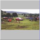
The B&B was okay but the couple who owned it (an ex-RAF type, but I reckon he was only the padré) were a bit strange and the food was bland and not in the huge quantities we were, by now, used to and needed. The beds were comfy, though. The real pests were the midges that made us cover up and keep all windows tightly closed. Noelene was very nice to Uncle and I , driving us into town for a couple of beers with Peter who was camping that night.
For me day twelve was a conquest. I'd walked further than ever before and had scaled the highest point of the Way. My feet were as sore as hell but that didn't seem to matter too much. I was appalled at the way some farmers despoil the countryside and by the awful, stony eight mile path down from Cross Fell. Garrigill was another of those idyllic villages on the very northern edge of the Pennines and I liked it a lot. In fact, Tony Hopkins book says that Alston is where the Pennines end and then there's no man's land to the Cheviots. The most spectacular part of the day had to be atop Cross Fell and the most picturesque, the walk along the South Tyne from Garrigill to Alston. Personally (sorry Mrs. Le Clair) I would recommend a B&B in the town itself.
We did well on day twelve. We put in a lot of miles and enjoyed doing it and you can't get much better than that.
Grub: Mince meat pie and vegetables Blackcurrent meringue and ice cream |
Booze: Black Sheep Bitter Flowers IPA Bitter |
![]() to go to Day
13,
to go to Day
13, ![]() to go back
to the itinerary or
to go back
to the itinerary or ![]() to return to the
starting page.
to return to the
starting page.